
Note! the HyperDAAC offers HyperLens as a viewer for Global Land Data from the EDC LandDAAC.
Development and Marketing Partners required
HyperLens is a radically new tool for scientific image visualisation, and particularly Remote Sensing. HyperLens brings a new level of interactivity to image viewing, and is particularly strong as a presentation tool for complex data.
HyperLens is based on 'Lenses', which are a variant on the classic Layers offered by most image manipulation programs. Lenses have the advantage that they can be dragged and resized, to offer different views on different areas of the image (or images). Lenses can contain any kind of data, information or processing you want: for more detail, see Layers and Lenses.
HyperLens is an Internet application. Because the HyperLens Client is written in JAVA, it can run as an applet from a web browser. But more importantly, it is built directly onto HTTP, the protocol of the Web, so it is truly a general-purpose Client tool for Internet GIS and other applications with demanding visualization and display requirements.
Finally, HyperLens is more than just an application: it is an extensible framework to which you can add your own functions, with an object-oriented Extension Framework that is both simpler and incomparably more flexible than the APIs offered by traditional applications.
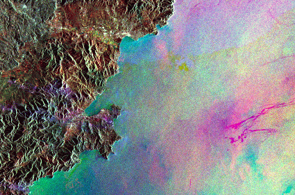
![[HyperLens - Screenshot]](geolens.gif)
The screenshot shows a small HyperLens window on a multitemporal SAR image of the Cote d'Azur. Each layer (Red, Green, Blue) shows a different date. At the right, a large oil slick is clearly visible in the green lens (19/9/91). Six days later (25/9/91) it has reached the coast, as we see in the blue lens. The thin line between the lenses is created by dragging the cursor, and controls the display of geographic information (below the image) in real time.
How much of that can you see in the image itself?
If your web browser supports JAVA 1.1, try it now for yourself.
![[Screenshot - Fragment from HyperLens]](thames.gif)
All the windows in the first example were filters on the original image. But lenses can equally be used to display different information sources, like GIS layers. The second example illustrates an Object lens with polygons and labels.
The image, a fragment taken from Remote Sensing Exercise 4 of Sea and Space, shows tidal sandbanks in the Thames Estuary. In the top left, the land is masked off using a solid polygon. At the bottom is a fragment from a map of the area.
If your web browser supports JAVA 1.1, try it now for yourself.
![[Screenshot - Fragment from HyperLens]](etna.gif)
This image of the cone of Etna uses SAR interferometry from the ERS Tandem mission: for details, please see ESA's Insar website. The Lens shows the IBP layer, but in the screenshot has been set to semi-transparent. The result is a view of the ILU image, in which the colourful interferometric fringes from the IBP product are clearly visible.
In other words, HyperLens is showing an interferometric measure of elevation changes superimposed on the "Land Use" image.
If your web browser supports JAVA 1.1, try it now for yourself. Don't miss the IVBP (Interferometric Visualisation Browse Product) - a new view made possible by HyperLens, using the IBP from ESA but bringing it to life!
Images copyright © the European Space Agency.